

O53A
New Philadelphia, OH, USA
The USArray component of the NSF-funded EarthScope project ended its observational period in September 2021 and all remaining close-out tasks concluded in March 2022. Hundreds of seismic stations were transferred to other operators and continue to collect scientific observations. This USArray.org website is now in an archival state and will no longer be updated. To learn more about this project and the science it continues to enable, please view publications here: http://usarray.org/researchers/pubs and citations of the Transportable Array network DOI 10.7914/SN/TA.
To further advance geophysics support for the geophysics community, UNAVCO and IRIS are merging. The merged organization will be called EarthScope Consortium. As our science becomes more convergent, there is benefit to examining how we can support research and education as a single organization to conduct and advance cutting-edge geophysics. See our Joining Forces website for more information. The site earthscope.org will soon host the new EarthScope Consortium website.


The EarthScope Transportable Array (TA) is a dense network of state-of-the-art seismic stations that, from 2004-2015, migrated across the contiguous 48 states recording the high-quality data needed to map the structure of the earth beneath North America. The project sponsored by the National Science Foundation (NSF) and deployed by Incorporated Research Institutions for Seismology (IRIS) already has made possible a growing body of significant, peer reviewed science that furthers our understanding of the continent, its formation, and its hazards.
The Transportable Array has since moved north to Alaska and western Canada. A few test stations were installed in 2011-2013 before deployment began in earnest in 2014. In all, TA’s Alaska phase comprises 280 stations and ran through 2021. The array is a grid of stations spaced about 85km apart covering all of mainland Alaska and parts of the Yukon, British Columbia, and the Northwest Territories (Figure 1). All stations have now been removed or transferred to existing networks including the Alaska Earthquake Center, Alaska Volcano Observatory, National Tsunami Warning Center, and Canadian Hazard Information Service.
The Transportable Array team planned to remove the remaining Alaska TA stations during the 2020 field season. Due to local, state, and federal travel restrictions in response to the pandemic and with the support of the National Science Foundation (NSF), IRIS postponed removal of most of these stations to the 2021 field season. Data telemetry was shut down May 1, 2021, and the Array Network Facility (ANF) continued to support archival at the IRIS DMC along with processing onsite baler media as it was returned from removals.
The timeline of operations, transitions, and removals for the Alaska TA stations was executed as follows:
A subset of Alaska Transportable Array stations have been transitioned to other network operators. Seismic data will still be archived and available via the IRIS DMC, with a change of network code and, in some cases, a change in sample rate or channel/location code. This might require adjusting data retrieval scripts. The full list of adopted or continuing Transportable Array stations is available under the virtual network _US-TA-ADOPTED.
Station hosts and the public can view data in webicorder or event views from stations or locate the nearest station with real-time data using the IRIS Station Monitor app.
A paper on the Alaska Transportable Array has been published in a focus section of Seismological Research Letters and is available online at: https://doi.org/10.1785/0220200154. An article about the stations that have been transferred to Alaska Earthquake Center is available here.
IRIS would like to thank the National Science Foundation for their continued support of the Alaska Transportable Array project through NSF Award EAR-1261681.
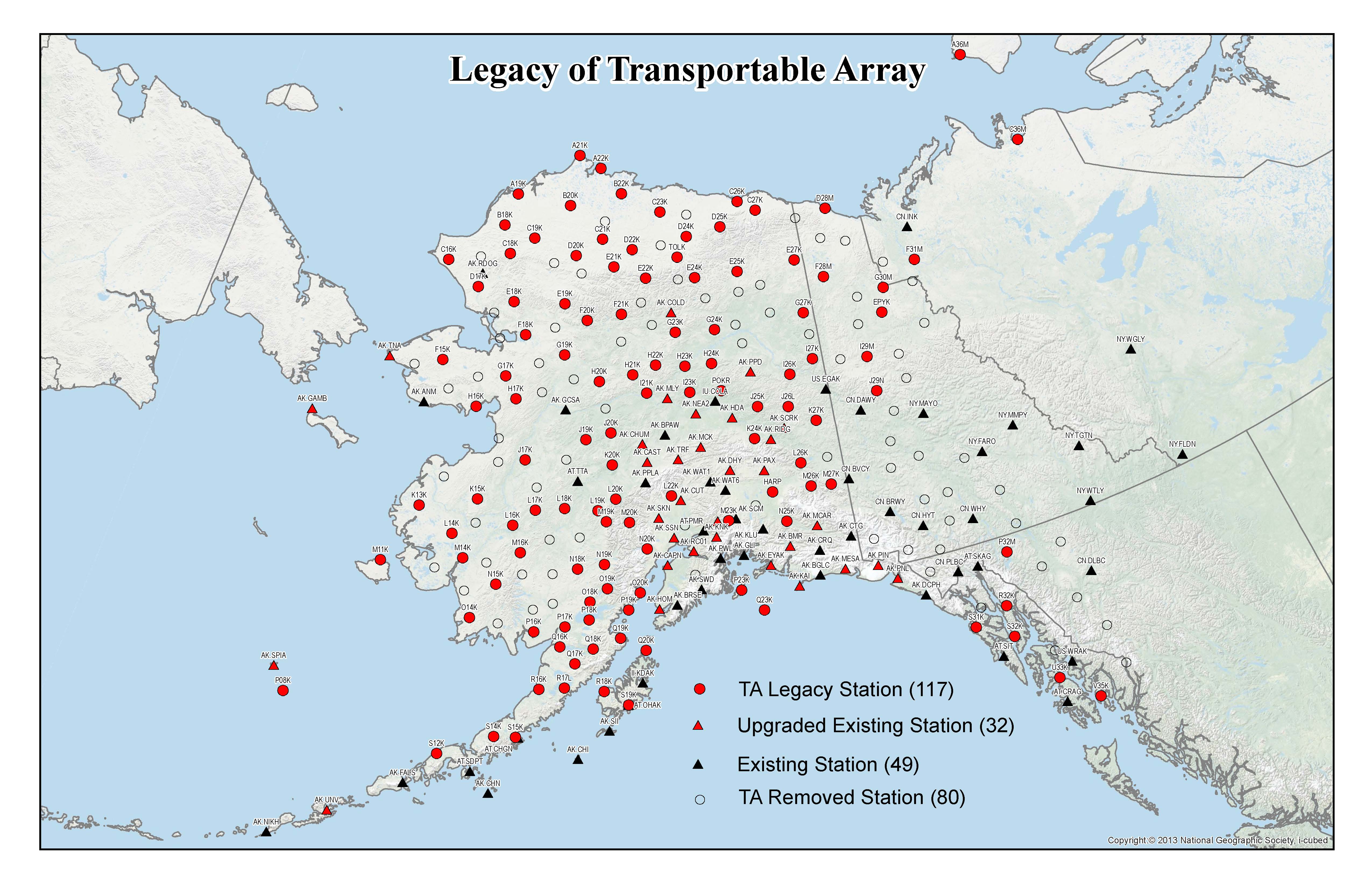
Figure 1: Complete TA Footprint and legacy stations. "TA legacy" sites (red circles) are continuing seismic stations, and exisiting sites are either upgraded (red triangles) or as-is (black triangles) contributing seismic stations. New TA stations that were installed and removed, instead of transferred, are shown as empty circles.
There were strong scientific motivations for shifting the TA to Alaska. Alaska is the nation’s most seismically active state, with more large and moderate earthquakes than the rest of the country combined. Furthermore, that seismicity is varied in nature and spread across the entire state (Figure 2), including regions that have never been closely monitored. The pre-TA instrumentation simply was not adequate for investigating the forces at play in many of the state’s far-flung regions. New TA stations have greatly increased earthquake detections in Southeast Alaska, Southwest Alaska, and the North Slope. As in the contiguous 48 states, this unprecedented station coverage makes possible new research into the structure of the earth beneath Alaska.
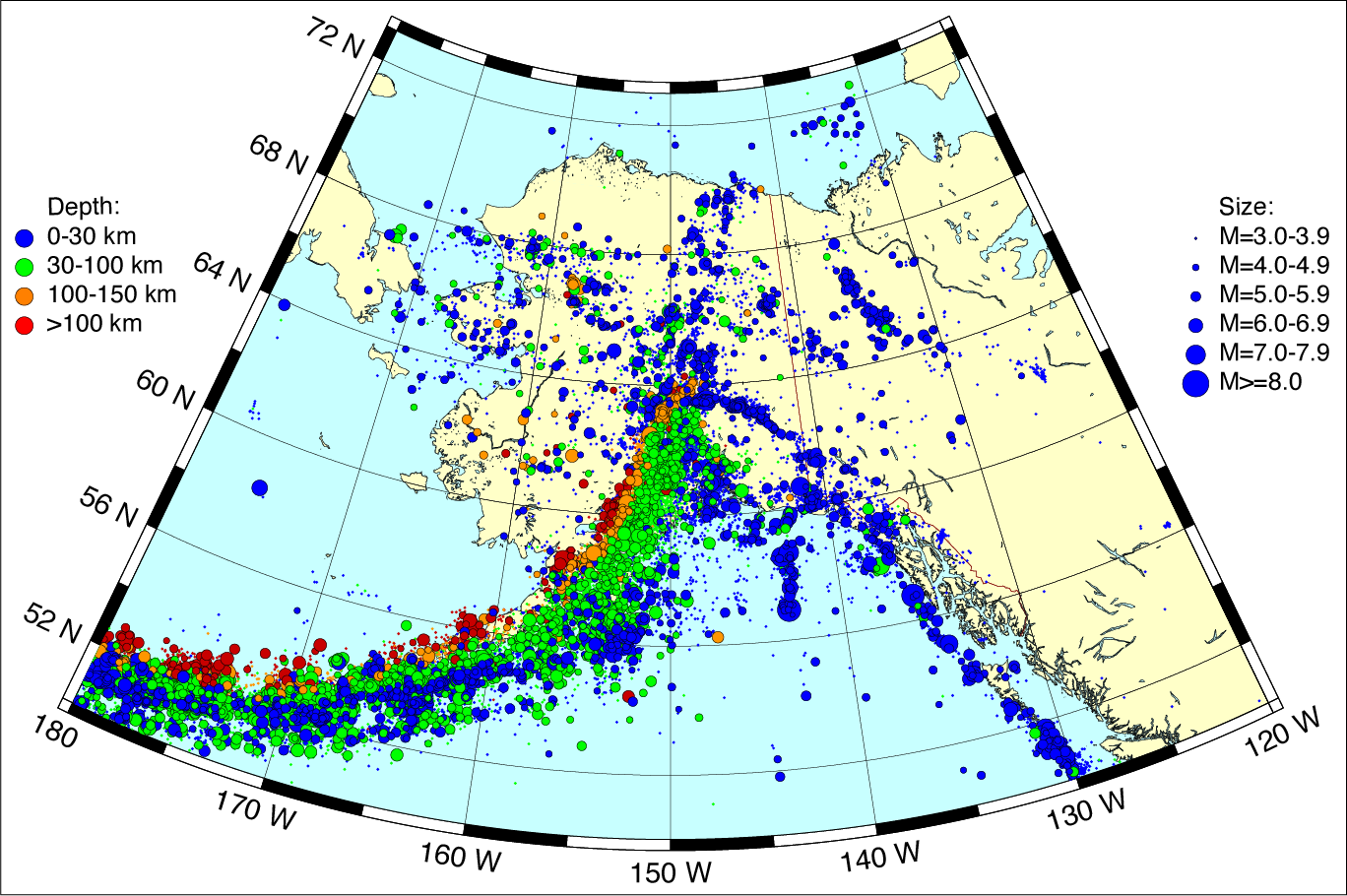
Figure 2: Seismicity from 1970-2012 for Alaska and vicinity from the Alaska Earthquake Center and USGS PDE catalogs, click for pdf. Figure courtesy of Natalia Ruppert (AEC).
Transportable Array stations were equipped with atmospheric sensors, including barometers and infrasound microphones (Figure 3). Because of the density of the TA network, this atmospheric data proved valuable for studying weather and atmospheric events in remote, sparsely monitored regions, as well as for wildlfire response.
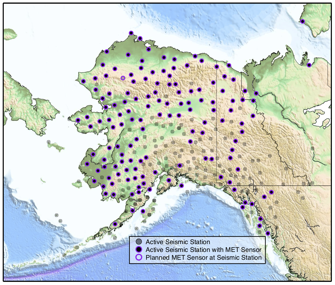
Figure 3: Locations of Meteorological (MET) sensors in the TA. Priority for co-located MET and seismic sensors was given to stations in remote areas that have not had meteorological sensor coverage before.
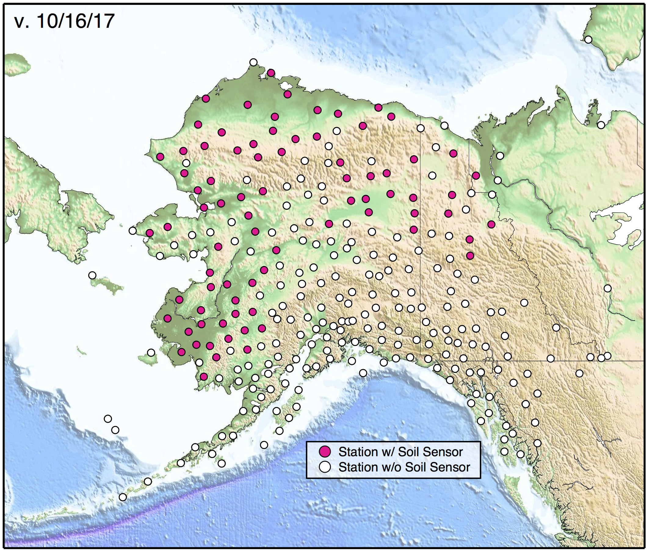
78 of the TA sites were instrumented with soil temperature profilers, the majority provided by the NASA ABoVE program but also by the Yukon Geological Survey. These stations complemented an existing temperature monitoring network, allowing for better characterization of ground temperatures and permafrost conditions in northern and western Alaska. Subsurface temperatures depend on many variables, including snow cover, vegetation, terrain, and soil properties. Mean temperatures for a study region may not account for “hot spots” of change, which can significantly contribute to thaw and associated carbon emissions. A solution is to record temperature regimes within different ecotypes in order to build a portfolio of subsurface thermal regimes across various ground conditions. The TA sites have been valuable for calibration and validation efforts and for informing thermal regime modeling. More information about this permafrost project can be found here.
Transportable Array data is publicly available via the IRIS Data Management Center and is utilized by the USGS National Earthquake Information Center and NOAA Tsunami Warning Center for real-time hazard monitoring. Additionally, many TA stations in the contiguous 48 states were retained as part of the separately funded project, Central and Eastern United States Network (CEUSN). Data from these stations is available from the IRIS Data Management Center with network code N4.
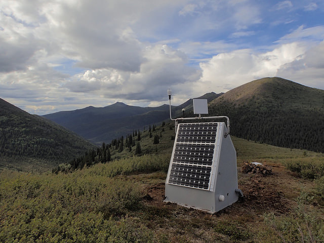
Alaska’s climate and geography demanded extensive station redesign to achieve the data return rates required for this project (Figure 4). Installing the sensors far enough underground for optimal data quality required designing a lightweight drill rig that could be flown to the sites by helicopter. Clusters of lithium iron phosphate batteries power the equipment through the long winter and are recharged by solar power systems during the summer. Most of the stations are located in wilderness, far from any telecommunications infrastructure. Near-real-time telemetry is provided by InMarSat BGAN, Iridium, cellular, or direct radio links. With datalogger capacities of up to 64 GB storage, stations can maintain a complete record from 8+ years of deployment.
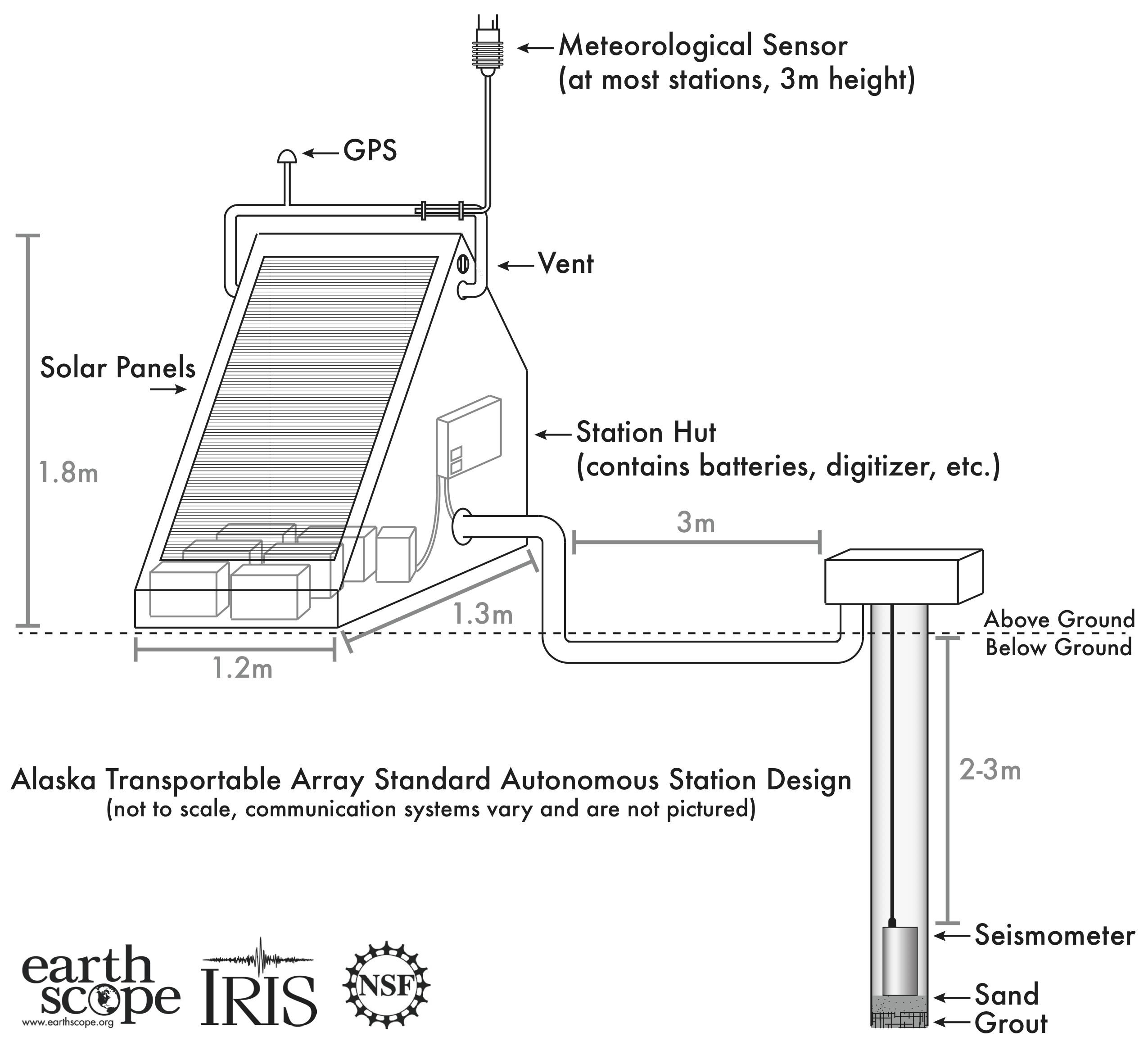
Figure 4: Schematic for an Alaska TA station, click to enlarge.
Each TA station’s seismograph system consists of a Quanterra Q330 datalogger connected to a three-component broadband seismometer (T120PH or STS-4B/5A) installed in a 6-inch diameter shallow borehole at a depth of about 2.8 meters. The standard TA atmospheric sensor package includes a MEMS state-of-health barometer, NCPA infrasound sensor, and SETRA microbarograph. Some stations also include a soil temperature profiler.
As an example of a typcial Alaska TA station, M29M was constructed and installed in just two days on July 26-27, 2016 along Somme Creek in the Yukon (Figure 5). The seismometer was installed using a down-the-hole hammer to drill a 2.7 meter steel cased hole into an igneous bedrock ridge line. For more photos of installation, see this mid-2017 field season report.
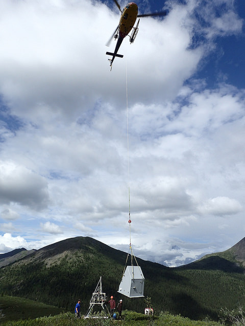
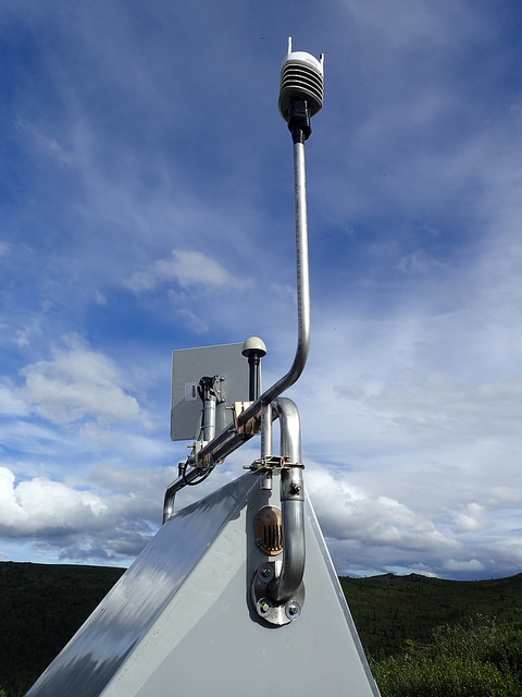
Figure 5. M29M construction (top left), weather sensor (top right), and final station exterior (bottom). Photo credit: Jeremy Miner
Operation of the Alaska TA ended in September 2021 with the removal of 80 stations. Fortunately, the legacy of the network will live on, through both the upgrade of over 30 existing seismic stations and the transition of 117 temporary Alaska TA stations into permanent stations that are now operated and maintained by the Alaska Earthquake Center, Alaska Volcano Observatory, Canadian Hazards Information Center, and Geological Survey of Canada. This path was established with the inter-agency-funded CEUSN in the contiguous 48 states, and was in line with the NSF Dear Colleague Letter: "Repurposing the Alaska Transportable Array to Support Observations of Arctic Environmental Change" and recommendations from the 2016 USArray Sustainability Workshop available at the ARCUS website.
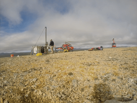
Figure 6. Typical Alaska TA station installs were constructed in a single day with a four-person crew plus pilots. The drill and station hut are helicopter portable so that stations can be constructed in very remote regions.
The USArray Transportable Array is sponsored by the National Science Foundation. The successful funding of the IRIS SAGE proposal made possible the TA’s redeployment as a single, static footprint in Alaska and northwestern Canada through to 2021. The Transportable Array Advisory Committee (TAAC) advised on the operation and technical performance of the TA in the context of EarthScope's science goals and changes in annual budgets.
The Alaska deployment of the USArray Transportable Array has cooperation and support from the Alaska Earthquake Center at the Geophysical Institute, University of Alaska Fairbanks. The AEC handles the telemetry and data acquisition for 54 stations in the Alaska TA network. Cooperation with the Canadian Hazards Information Service, Yukon Geological Survey, and Natural Resources Canada has also been vital to extending TA stations across the border.
The investment of EarthScope directly benefits other seismic network operators in Alaska, many of which are focused on characterizing seismic, volcanic, and tsunami hazards. IRIS also works with the Alaska Earthquake Center, Alaska Volcano Observatory, and the Alaska Tsunami Warning Center to upgrade and leverage existing seismic infrastructure and permitting wherever possible. IRIS is keen to collaborate with members of the Arctic science community during the development and implementation of USArray in Alaska.
Publications related to the Transportable Array in Alaska, including development plans and regional fact sheets, are available online here.
Gardine, L. and N. Ruppert (2020). Alaska Earthquake Center’s Seismic Network Covers New Ground
USArray-Alaska Extension into Northwestern Canada Workshop Report (2013)
Autonomous Polar Observing Systems Workshop Report (2011)
Opportunities for EarthScope Science in Alaska in Anticipation of USArray Report (2011)
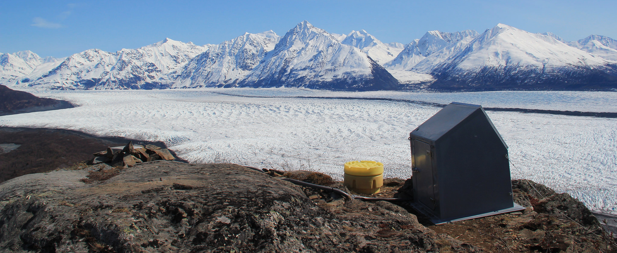
Alaska TA equipment installed at the Knik Glacier Alaska Earthquake Center station (5/12/2015)

