

K04D
Chiloquin, OR, USA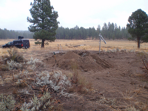
The USArray component of the NSF-funded EarthScope project ended its observational period in September 2021 and all remaining close-out tasks concluded in March 2022. Hundreds of seismic stations were transferred to other operators and continue to collect scientific observations. This USArray.org website is now in an archival state and will no longer be updated. To learn more about this project and the science it continues to enable, please view publications here: http://usarray.org/researchers/pubs and citations of the Transportable Array network DOI 10.7914/SN/TA.
To further advance geophysics support for the geophysics community, UNAVCO and IRIS are merging. The merged organization will be called EarthScope Consortium. As our science becomes more convergent, there is benefit to examining how we can support research and education as a single organization to conduct and advance cutting-edge geophysics. See our Joining Forces website for more information. The site earthscope.org will soon host the new EarthScope Consortium website.

Principal Investigators and Institutions:
Simon Klemperer sklemp@stanford.edu (Principal Investigator)
Elizabeth Miller (Co-Principal Investigator) Stanford University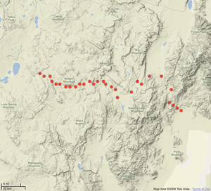
Funding Source:
NSF EarthScope
Field Dates:
9/2004 – 4/2005
Equipment Used:
29 short period stations
Data Status:
Archive Complete
Data released
Network Code:
YQ
Description:
Nevada has high topography - even the valleys between the mountain ranges are at elevations of several thousand feet. Because this average elevation does not change significantly between the Oregon border and central Nevada, we believe that the Earth's crust (colloquially, the iceberg floating on the mantle) must be the same thickness across this region. What is remarkable, however, is that we have discovered that the amount of extension - the amount of stretching of the crust by faulting at the borders between the mountains and the valleys - increases by a factor of about 5 as we go south across this same region. When the crust is stretched it thins, so why then is the crust not thinner, and the elevation lower, in central Nevada? This is the "extension paradox" that we are studying.
We believe the answer may be that the lower part of the crust is weak enough that it can flow over geological timescales, and that the lower crust beneath northern Nevada is flowing south to central Nevada, helping to equalize the crustal thickness and balance the elevations across this region. We are testing this hypothesis by collecting a new seismic profile that will measure the crustal thickness and structure in great detail across northwestern Nevada, a region that has not been well-studied by this method in the past. We are making use of the latest technology and equipment that has recently been developed and acquired for the national scientific enterprise by NSF's Earthscope program. Earthscope, through one of its divisions "US-Array", has funded the development of a "FlexArray", a large pool of easily transportable seismographs. We will use this new equipment to study the Earth's crust in more detail than has previously been possible - we expect to lay out over 1000 seismographs to record the sound waves created by 6 explosions that we will detonate at precisely controlled times and locations. By measuring the time it takes for the seismic waves to travel through the Earth's crust from each explosion to each seismograph, we can build up an accurate picture of the seismic wave-speed through the Earth, which in turn lets us map out the different rock types and structures present at depth.
During our project we are training a group of Stanford undergraduates in the combination geologic and geophysical techniques required to understand the continents. By extending the classroom from campus to the Nevadan deserts and mountains, and by extending theory to practice, we are enriching the education of the next generation of scientific leaders. We are also working with Bureau of Land Management and National Forest managers to carry out a safe experiment with no lasting environmental impact, and in so doing we expect to enlarge public understanding of scientific methodologies, and public appreciation of local geology. All our data will be archived with and publicly released through an Earthscope Data Center; ultimately our new understanding of the crust beneath northern Nevada will help us and other scientists better understand earthquake hazard in this region.
Publications/ Abstracts
Lerch, D.W., Klemperer, S.L., Egger, A.E., Colgan, J.P., and Miller, E.L. The northwestern margin of the Basin and Range Province, Part 1: Reflection profiling of the moderate-angle (~30°) Surprise Valley Fault: Tectonophysics

