

Q23K
Middleton Island, AK, USA
The USArray component of the NSF-funded EarthScope project ended its observational period in September 2021 and all remaining close-out tasks concluded in March 2022. Hundreds of seismic stations were transferred to other operators and continue to collect scientific observations. This USArray.org website is now in an archival state and will no longer be updated. To learn more about this project and the science it continues to enable, please view publications here: http://usarray.org/researchers/pubs and citations of the Transportable Array network DOI 10.7914/SN/TA.
To further advance geophysics support for the geophysics community, UNAVCO and IRIS are merging. The merged organization will be called EarthScope Consortium. As our science becomes more convergent, there is benefit to examining how we can support research and education as a single organization to conduct and advance cutting-edge geophysics. See our Joining Forces website for more information. The site earthscope.org will soon host the new EarthScope Consortium website.

Principal Investigators and Institutions
Gary Pavlis, Indianna University at Bloomington
Hersh Gilbert, Purdue University 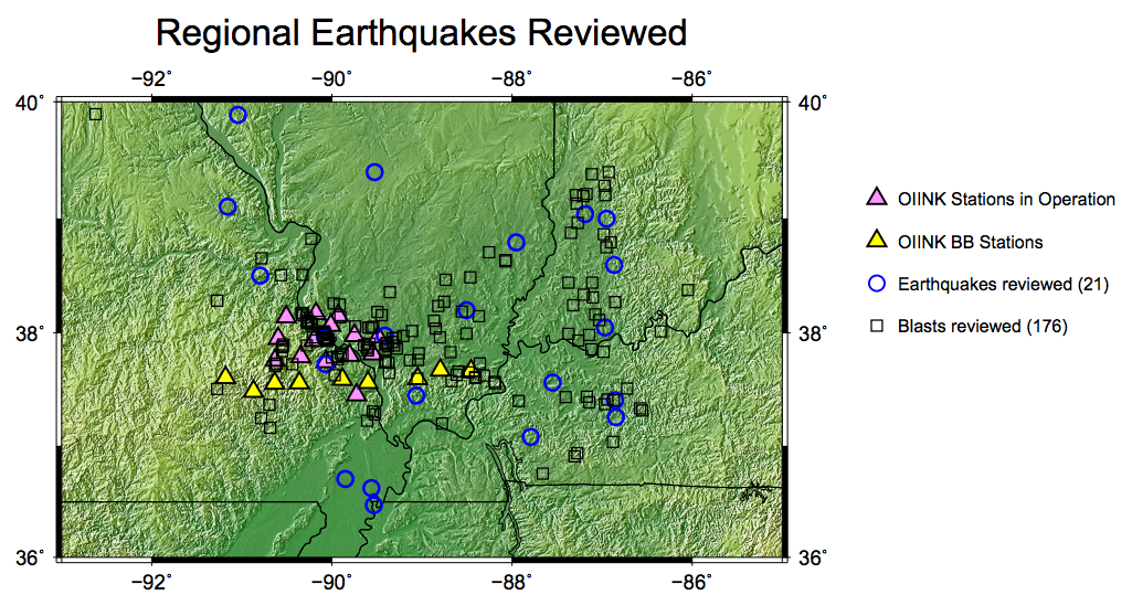
Funding Source:
Earthscope-Science Utilization
Field Dates:
7/2011 – 12/2015
Equipment Used:
23 Broadband Stations
Data Status:
Archived 1-2 Service
Network Code:
XO
Description:
This project is directed at improving our understanding of the lithosphere-scale structure of North America's stable continental interior (Midcontinent cratonic platform). The study area includes some of the world's best examples of cratonic platform lithosphere structures. Specifically, it spans the Ozark Dome and the Illinois Basin (including the abrupt boundary between them along which the Precambrian/Cambrian unconformity displays over 7.5 km of structural relief), as well as the Rough Creek Graben and other major fault zones including the Wabash Valley Seismic Zone. It also crosses major Proterozoic sutures and the enigmatic Eastern Granite-Rhyolite province. The study is intended to address seven fundamental tectonic issues: (1) structure of intracratonic uplifts and basins; (2) Proterozoic assembly of the North American cratonic platform; (3) deep structure of intracontinental rifts and fault-and-fold zones; (4) lithospheric controls on intraplate seismicity; (5) deep structure of the midcontinent?s unusual anorogenic granite-rhyolite province; (6) structural and lithospheric controls on ?cratonization? of the North American platform; and (7) understanding the nature of the strong gravity and magnetic-field anomalies in the region.
The project is focused on operation of a three-dimensional, broadband, passive seismic array centered over the Illinois Basin. The array is embedded within the Earthscope Transportable Array, and is designed to provide enhanced resolution of subsurface structures in the region. The experiment involves deployment of 120 temporary seismograph stations over a 3-year period coinciding with the operation of the Transportable Array in the area; site occupation will roll in four distinct stages using a maximum of 60 simultaneously operating stations. The acquired seismic data are being analyzed using a variety of state-of-the-art seismic analysis tools: travel-time tomography using teleseismic P and S waves; wave-field imaging using industry-developed methods of stacking signals to improve signal-to-noise ratio and ?migration? of inferred seismic sources to their proper geometric position; and a detailed analysis of seismicity recorded on this dense array, to better locate earthquake sources and characterize faults. Estimates from previous work in the area suggest that approximately 100 local earthquakes and 12,000 mining explosions will be recorded during the course of the three-year field experiment.
The project also incorporates an integrated education and outreach component, involving: (1) in-service teacher workshops designed to expand the pool of master teachers knowledgeable about EarthScope science; (2) a teacher Research Fellows program to include high school science teachers in summer research teams; (3) involvement of students and the public in EarthScope-related activities using already established connections with schools, pre-college research symposia, and State Survey outreach programs (field trips; open houses; public presentations); (4) development of material for "Active Earth" displays for regional outreach, and for incorporation in widely used introductory geoscience textbooks; (5) engagement of undergraduate students through a Research Experience for Undergraduates program; and (6) graduate student education three research universities.

